From Coordinates to Condition Reports: How Geospatial Technology Is Reshaping Asset Management

What used to require frequent visits to analyze the present condition of construction work, popular buildings, infrastructure and other physical assets is now being done with just quick and live insights. With the help of advanced tools, professionals can interpret and visualize the world while sitting in their office.
Must be thinking – ‘how?’ With geospatial technology! It has a wide range of modern tools and applications that can help asset management not just be limited to coordinates – but expanded to condition reports.
Operations have gone smooth, workers get real time reports from the professional who lacks time to always be available on the location – either within the country or abroad. Just a decade ago, it used to be the major cause of why even experienced professionals used to struggle with their time management.
Keep reading this article that will help you understand how these location intelligences are working as a foundation to deliver the precise details needed for effective decisions – from coordinates to conditional reports.
The Foundation: Turning Addresses Into Actionable Data
Each physical asset is located in a particular place. Whether you are dealing with a portfolio of commercial properties, managing utility infrastructure, or overseeing logistics operations, understanding exactly where your assets sit on the map is important.
This is where geocoding becomes essential. A geocoder converts street addresses into latitude and longitude coordinates, creating the spatial framework needed for mapping, evaluation, and reporting.
The process works in both directions. Forward geocoding transforms an address like “152 Elizabeth Street, Melbourne” into precise coordinates, while reverse geocoding does the opposite, converting coordinate pairs back into readable addresses.
Why does this matter for asset management? Consider a facilities manager overseeing hundreds of properties across multiple cities.
Without geocoded data, their asset register is just a list of addresses. With geocoding applied, that same register becomes a visual map showing geographic patterns, grouping opportunities, and logistical efficiencies.
Modern geocoding tools handle batch processing with remarkable speed. Thousands of address records can be converted to coordinates in minutes, enabling rapid analysis of large property portfolios.
Accuracy matters greatly in this context. Poor geocoding can place assets in the wrong locations, leading to inaccurate analysis and incorrect decisions.
Industry-grade geocoding solutions use frequently updated reference datasets. This ensures address matching remains reliable even as new developments emerge and street layouts change.
The output formats are equally important for professional workflows. Quality geocoding tools export results in formats compatible with major GIS platforms, allowing effortless interaction with existing mapping and analysis systems.
For organizations working across Australia and New Zealand, regional data quality is particularly crucial. Local geocoding specialists understand the specifics of address formats and administrative boundaries in these markets.
Beyond the Map: Capturing Physical Reality
Knowing where an asset is located represents just the starting point. Understanding its actual physical condition requires a different set of tools entirely.
Traditional building inspections presented significant challenges. Accessing rooftops, facades, and elevated structures meant scaffolding, rope access, or expensive crane hire.
These methods were slow, costly, and sometimes dangerous. They also provided limited coverage, with inspectors only able to examine what they could physically reach.
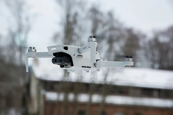
Technology has fundamentally changed this equation. Aerial platforms equipped with high-resolution cameras and sensors now capture comprehensive imagery of structures that would otherwise require extensive access equipment.
The applications span virtually every type of built asset. Commercial office towers, industrial facilities, bridges, transmission infrastructure, and heritage buildings all benefit from this approach.
High-rise structures present particular advantages for aerial inspection methods. Examining a 40-storey building facade traditionally required building maintenance units or extensive scaffolding installations.
Modern inspection technology reaches these heights in minutes rather than days. The resulting imagery captures details across the entire structure, not just the sections accessible from fixed platforms.
Confined spaces represent another area where technology excels. Roof cavities, utility tunnels, and mechanical spaces often present access challenges and possible dangers for human inspectors.
Remote inspection platforms navigate these environments safely. They capture visual data without exposing personnel to risks or requiring costly confined space entry procedures.
The quality of captured data has improved dramatically. Current systems deliver imagery sharp enough to identify hairline cracks, early-stage corrosion, and subtle water damage indicators.
When combined with 3D scanning technology, inspections produce dimensional models accurate to millimetre tolerances. These models support detailed analysis, measurement, and comparison over time.
For asset managers and building owners,drone building inspection services deliver faster turnaround, reduced costs, and more comprehensive coverage than traditional methods.
The inspection reports themselves have evolved accordingly. Geo-tagged imagery links findings to specific locations on the structure, creating clear documentation for maintenance planning and compliance records.
Connecting the Dots: Integrated Workflows
Geospatial technology has become a must to have technological advancement for precise and real time decision making across industries – from asset management to environmental science. Through its accurate reporting – geospatial technology became a game changer for asset management. It reduced emergency maintenance costs, gave access to preventative interventions, ensured safety regulations and complaints are met accordingly and optimized the lifespan of critical infrastructure.
It is a lot more than just a surveying tool – it is a modern solution for coordinates based asset management. It has empowered the organizations to map, monitor and maintain infrastructure with accuracy.
Ans: No – it is benefitting a wide range of organizations ranging from asset management to environmental science.
Ans: It will convert those records into coordinates within minutes. This will allow you to address long reports with quick analysis.
Ans: Yes, geocoding needs to be very accurate for the real time results. Otherwise, the results may vary a bit.